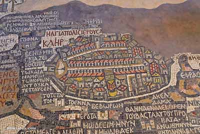
Le Cardo de Jérusalem

Aussi connu sous le nom de Cardo Maximus

Carte à Madeba de Jérusalem

Carte de Madaba

Se trouvant au sol d'une église de Medeba en Jordanie et datant du VIe siècle, cette mosaïque illustre une carte du territoire d'Israël mentionnant de nombreux lieux en grec.

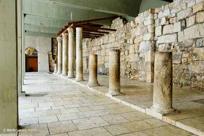
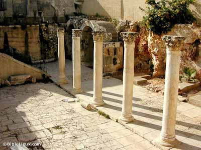
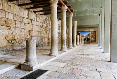
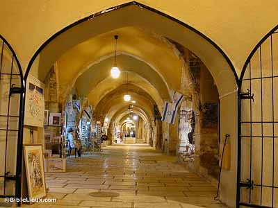
Le centre de la carte dépeint Jérusalem et les murs de la citée, ses portes, ses églises (aux toits rouges), et son Cardo, vus à vol d'oiseau. Cette allée principale traversant la ville de nord en sud possédait deux rangées de colonnes longeant ses deux cotés.


Excavations

Découvert par l'équipe de Nahman Avigad dans les années 1970, le Cardo du quartier juif fut mis au jour sur environ 200 mètres. Cette partie (photo) date de la première moitié du VIe siècle, de l'époque de l'empereur Justinien. Une portion antérieure fut construite lors de l'ère romaine et commençait à l'emplacement moderne de la porte de Damas au nord de la ville. Cependant celle-ci ne s'étirerait autant au sud que quelques siècles plus tard.

Le Cardo vu du nord


Le Cardo, vue vers le sud-ouest

Rue Principale

La rue centrale du Cardo,  large de 12 mètres, est longée des deux cotés par des colonnes. En incluant les commerces se situant des deux côtés de la rue on atteint une largeur totale de 22 mètres, l'équivalant d'une autoroute à quatre voies. Principale voie de communication de la Jérusalem byzantine, cette rue servit aux résidents comme aux pèlerins. A de nombreux endroits des églises s'élèvent sur ses flancs.


Aire de Commerce

Les colonnes supportait un toit en bois (non conservé) qui couvrait les commerces, protégeant les acheteurs du soleil et de la pluie. Aujourd'hui la rue byzantine est à peu près à 6 mètres au-dessous du niveau de la rue actuelle: une indication du degré d'accumulation des 1400 dernières années.

Le Cardo vu du sud


Allée de commerce du Cardo vue du sud

Magasins Modernes

Une partie du Cardo a été rebâtie en ruelle de magasins modernes. Les magasiniers juifs y vendent des souvenirs de toutes sortes aux touristes à "bon marché". Cette ruelle continue au nord jusqu'à la porte de Damas, quittant le Quartier juif pour marquer la division entre les Quartiers Chrétien et Musulman. Comme dans l'ancien temps cette rue reste la principale de la Vieille Ville, étant néanmoins bien plus étroite qu'elle ne le fut jadis.

Autres Sites Web

Sur BibléLieux.com, voir page sur le Quartier Juif, pour plus de photos, de texte et de liens.

The Cardo, General:

The Cardo (The Department for Jewish Zionist Education)  Lengthy description of the history of the site, including many photos.

The Cardo (The New Jerusalem Mosaic, Hebrew University)  A brief history of the ancient thoroughfare and its excavation by Nahman Avigad.

The Cardo (Agency for Jewish Education)  Explanatory text conveys the history and location of the Cardo.

The Emperor Justinian and Jerusalem (527-565 CE) (The New Jerusalem Mosaic, Hebrew University)  Focuses on the reign of the sixth-century emperor who, among other large scale projects, expanded and magnified the Cardo.

Jerusalem in Early Christian Times (Israel MFA)  Highlights various facets of life in Christian Jerusalem, including a glimpse into the Cardo of this time, section by section.  Features many photographs and reconstruction drawings. 

The Empire Strikes Back in Jerusalem's Cardo (Jerusalem Post)  Retells the story of the "Christian" Emperor Hadrian's glory days from a Jewish perspective.  This thought provoking article walks the reader down the present day remains of the Cardo and ends with a triumphant conclusion.

Jerusalem through Jewish Eyes (Jerusalem Post)  Reviews a book written for those who desire to find the scanty Jewish sites in the city dominated by Christians and Muslims for the past two millennia.  Highlights the Jewish roots connected with the Cardo by way of example.

Jerusalem: The Eternal City (Israel MFA)  Spotlights important archaeological sites around Jerusalem, including the Cardo.  Includes an enlargeable photo of  each site featured.

The Cardo (Personal Page)  Recounts the personal experience of one college student  traveling this historic route. 

The Cardo in the Old City - Jerusalem (3Disrael, inisrael.com)  Another 360 degree panoramic photograph viewing the indoor portion of the Cardo.

Jerusalem (University of North Florida) A basic directory of Jerusalem pictures.  Access to pictures is provided through this link, but navigation is possible only by using the "back" button on your browser.  The first five pictures pertain to the Cardo. 

The Medaba Map & the Cardo:

Jerusalem - the Nea Church and the Cardo (Israel MFA)  Discusses the role of the Medeba Map in recovering the Nea Church and the Cardo.  Includes a section highlighting the history and archaeological sites of the Cardo.  Copy of this page at Jewish Virtual Library.

Byzantine Jerusalem and the Madaba Map (Personal Page)  Reviews the Byzantine history of Jerusalem through a glimpse at the Jerusalem medallion in the Medeba Map.

Jerusalem on the Madaba Map (The New Jerusalem Mosaic, Hebrew University)  Glimpses Jerusalem through the eyes of the famous Byzantine period map.

The Menorah

The Menorah (The Temple Institute)  Details the biblical instructions and details of construction of the menorah.  Brings to light contemporary discussion on some of the structural details. 

The Menorah (Restoration Foundation)  Discusses some of the issues relating to the structure of the original menorah based on archaeological discoveries with conflicting images. 

Good and Light of the Gold Menorah (All-Ukrainian Jewish Congress)  A press release, celebrating the dedication of a golden menorah created by the Jerusalem Temple Institute.  The menorah is considered by some to the be the first step toward the building of the Third Temple. 

Third Temple Menorah Unveiled In Jerusalem (Bridges for Peace)  A brief article reporting on the unveiling of the Temple Institute's new menorah.